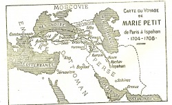
I need to update and enlarge this map from H. Aurenche and L. Coquet's historical novel about Petit's journey, La Brelandiere. Ambassadrice du roi soleil (Paris: Nouvelles Editions Latines, 1945). I can't identify some of their place names, in particular 'Karpoula,' just outside of Erivan, supposedly the site of the Khan of Erivan's summer residence. I've just noticed that a limited preview of Aurenche and Coquet's book is available on Google books here. Anyway, until I can get some map creator software downloaded and do my own map, this one will have to suffice to give you an idea of her journey. I'd also like to be able to overlay the map with information about things like distance between places, dates of each stage of the journey and methods of travel.
